Wild Camping along the North Downs Way Section 6: Otford to Cuxton
Here we are, finally, day one of five, wild camping along the North Downs Way, and like every great British outdoor adventure, it had to start with rain, naturally, otherwise it wouldn’t be fun. Why would anyone want to start their day with dry gear and clothing? Ridiculous thought! Unlike my Lake District endeavour though — which marked the end of the 2020 heatwave with rain setting in as soon as I opened the door to head up North — it was part of the plan this time around.
I elaborated on my planning efforts in my previous post, researching good places to camp, mapping out distances that can possibly be covered within a day considering the weight we’ll be carrying, as well as the daylight hours available to cover some ground. It was early October and we were not too keen on setting up our tents in complete darkness, nor in torrential rain, something we got to avoid, at least in the beginning.

While getting ready within two days already seemed like a push, starting a day earlier to cut the first long section in half was another option we discussed but quickly discarded when looking at the weather, another thing to consider when making plans. The forecast convinced us to rather start early and walk through the tail end of the storm instead of carrying a wet tent after the first night already. After all, our backpacks were heavy enough. Well, at least mine was.
I think I quoted Plato before when chatting about the beauty of camping, making you realise that “[t]he greatest wealth is to live content with little” — still something I fully agree with, and that morning, when rocking up at the station, I wish I’d adhered to when packing because ‘content’ is not quite the word that came to mind back then, unless we’re talking about cutting my backpack ‘content’ in half. I mentioned rookie mistakes before, here comes the first one.
Given Ian’s offer to carry some of my heavier bits until we split in Boughton Less as I had more supplies to carry and no cosy hotel bed to look forward to, I ended up with about 18kg on my back, similar to the Lake District weekend, plus a little carrier bag with treats, lunch and breakfast. Since we left on a whim, I also swiftly cooked up anything that would have gone bad in my absence and used it as supplies for day one, not the most weight efficient solution adding another 3.5kg to the lot — but luckily, I had relief awaiting me at the station, or did I?
Poor Ian, the story hasn’t even fully started yet and I already give him grief. Truth be told, he did later on offer to carry some of my bits once he had some space in his tightly packed bag. By then, I think I already got conformable with my chosen destiny and aching hips. Weirdly enough, and despite the internal muttering at the start, it turned out to be a blessing in disguise because it showed what you’re capable of when not given a choice, the perfect pandemic remedy, while being an opportunity to reassess outdoor packing and eating habits, possibly making upcoming trips (which might be more remote and completely solo) even easier. So technically, I guess I should rather thank than scold him, and as mentioned before, I was truly grateful for the company, tiny backpack or not.
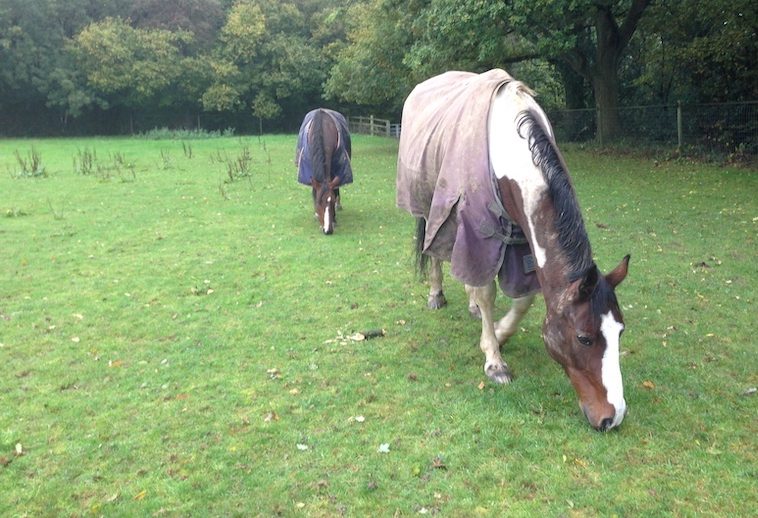
It was actually quite funny, seeing people’s faces when we came out of Otford Station. I didn’t notice at first but Ian pointed out that they probably wondered about the weight distribution seeing the two of us, especially after I added the small carrier bag to my load. It made my backpack slightly tower over my head, like a little kid wanting to have a peek where we’re heading. Good thing it only rained and wasn’t very windy, one unexpected blow from the side and I would have been glued to the ground like a tortoise on its shell, limbs in the air, head withdrawn in shame — luckily a mishap I do not have to report on.

Section 6: Otford to Cuxton, 15 miles (24.1 km)
We decided to meet relatively early because we had lots of ground to cover. Plan A, (A for ambitious perhaps), required us to reach Blue Bell Hill for the first night, one of the places I found during my wild camp research, which would have also been ideal for Ian giving him loads of time to stroll to Canterbury while I continued my journey to Dover.
Blue Bell Hill was past Cuxton, adding another 6 miles to the distance — that’s right, 21 miles in one day. Easy, right? I did say it was an ambitious plan, okay okay, a ridiculously ambitious plan. When looking at the numbers, I probably thought of the day when I walked from Westhumble to Oxted, 18 miles (29km) in one go plus public transport getting me there and back, gained journey time that could be used for walking and make up for the reduced pace due to the ‘insignificantly’ bigger backpack.
No need to leave it till the end as I might have hinted at it before — we did not make it, surprise surprise. We didn’t even make it all the way to Cuxton, the end point of section 6, shocker?! We ended up camping just a few miles before it, probably about 3 miles away which meant that we covered about 12 miles (19 km) that day, which makes sense as the average walking pace can range from 2-4 mph (3-6 km/h). If on a mission and on your own, you’re probably in the higher range. In walking groups, you tend to drop down to the middle or lower range of about 2.5 mph (4 km/h) depending on fitness levels and the terrain you’re facing. Then adding a camping backpack to it and you’ll probably find yourself at the bottom, at least for the first day(s) as you’ll lighten your weight one food stop at a time, something I always look forward to. Fighting the temptation to not eat everything on day one — who am I kidding, on the train ride even — is always the first challenge of the adventure.
But enough about pacing yourself and shedding some weight, what can you expect when walking along this section, be it for a day walk or overnight endeavour.
From Nature Reserve, to Manor House, to Market Town
Almost being the perfect metaphor for our improvised camping trip, and pandemic life in general, section 6 is made up of many ups and downs, as you’ll continuously switch between the high-level track at the top of the Downs, semantically rather mind-boggling if you ask me, climbing ‘up’ the ‘Downs’, to then lower down to the Pilgrims Way, which I mentioned before. For the ones that just joined, it’s the historical route from Winchester to Canterbury Cathedral in Kent following a pre-existing ancient trackway along the lower slopes of the North Downs for about 119 miles (192 km).
Again, if you find yourself on the Pilgrims Way along your journey, you’re either spot on or not far off. So, keep going and enjoy the Kemsing Down Nature Reserve, the first highlight of this section, known for its numerous species of orchid, over nine the guidebook says, in case you’re into plants and that’s an impressive number. Otherwise, you might also get to be distracted by one or the other butterfly flattering by, another attraction of the reserve, along with an extensive view ranging all the way from Detling in the east to Leith Hill in the west. The latter you might remember from my wild camping intro referring to a Meetup hike leading us there for lunch. It’s actually the highest summit of the Greensand Ridge and second highest point in southeast England with 294 m (965 feet) above sea level (after Walbury Hill in southwest Berkshire), a fact I learned the other day on a less bootcampy and more informative stroll around Surrey, which led me to the lovely Edwardian estate, Polsden Lacey, also located on the North Downs, near Dorking, not too far from Denbies, proud owner of the largest vineyard in England — in case you need some inspiration for your next weekend stroll.
No vino for us during section 6, (not until the evening at least), nor clear skies, something you need to be able to see as far as Leith Hill, a sight we weren’t lucky enough to enjoy. The weather forecast was spot on, continuous drizzle led the way not even tempting any cheeky butterflies to come out and play. Instead though, I do recall a rather magical moment when walking through an opening, winds getting stronger the further we went, giving me a slight push while also picking up loose leaves from the ground, making them twirl around us. I remember reaching out, trying to touch them as they danced through the air, seeming to have a life of their own as they accompanied us for a little while, until we disappeared in the woods again, which offered shelter from the initially dreaded weather now offering its very own perks.
While outdoor adventures tend to be more popular in the summer months, its actually quite nice to occasionally experience the characteristics of the less comfortable seasons as they all seem to have their own personalities some might say. And this playful moment of nature welcoming us to its realm definitely set the scene and made me wonder what else this autumnal journey might have in store for us.


In terms of terrain, my curiosity got instantly satisfied as we were greeted with another steep climb up to Otford Mount, leading yet again along the high-level track and past Otford Manor, a sight that might be of interest to Brits that like their tea sweetened as it was built in the 1930s for Sir Oliver Lyle, a sugar technologist and member of the Lyle family, who contributed to the Tate & Lyle sugar fame.
Once you get past that little sugar high, you’ll descend, again, to join the Pilgrims Way to Wrotham, pronounced ‘Rootam’ if you ever try to read this out loud, and enjoy shaking your head at the confusing English language. That village with the unnecessary ‘W’ was once a market town dating back to the 8th century. The market has gone unfortunately, as it grew into a large village with around 2,000 people (500 more than my own glorious hometown) who are now being contained by two motorways, the M20 and M26, rather than market stalls.
A shame really but that’s the way the cookie crumbles, so might as well move on swiftly, or as fast as your little legs let you, as another ascent lies ahead leading through Trosley Country Park luring you in with its chalk grassland, more butterflies and a rare musk orchid, or Herminium monorchis for the botanists among us, or Harry Potter fans wanting to add an easy-to-remember orchid type to their colourful vocabulary.
Another paragraph, another descent, back onto the Pilgrims Way, but only briefly, before heading up again into Rochester Forest, a heavily wooded area making you forget for a little while where you are, in a good way, before reappearing from the shadows when walking through two deep valleys and the hamlet of Upper Bush leading straight to the outskirts of Cuxton, the end of section 6.
By now you already know, we did not get that far, and Blue Bell Hill, the ambitious first campsite I had my eyes set on was definitely out of the question, something we realised halfway through the day wherefore we decided to take advantage of Rochester Forest’s remoteness. As trail sections tend to start and finish close to civilisation and public transport, which makes them perfect for day trips, you’d either want to overshoot the end point (Plan A), or settle just before, Plan B — one we were quite happy with in the end when pitching our tents at one of the openings around Pastead Wood, just before Dean Farm if you have a closer look at the map, the first thing we passed the next morning.
From Rain to Drizzle, to Pain, to Tipple

As anticipated, the rain had stopped towards the late afternoon and the sun occasionally peeked through the clouds drying the opening where we decided to lay our heads after we wolfed down our first camping dinner followed by a well-deserved treat which was worth the additional weight, something I say now that the memory of the aches and pains back then has faded, the brain is funny that way. It wasn’t that bad though, otherwise I would not have kept going and met Ann and Trian Wallace along the trails, a lovely encounter I still remember in detail as it made my internal struggles seem less significant as they admired my courage and determination to wild camp my way to Dover.
It left me with a spring in my step, metaphorically — no spring left in my joints that day — to carry on and finish the day on a high, one we raised our glasses (or flasks rather) to which were filled with a bit of port, that terribly impractical treat I decided to schlep along, which came in more handy than expected as we sat outside our tents for quite a while discussing the day’s highs and lows, the ones the trail itself offered as well as the struggles both of us brought along with us. We discussed our impressions of the day, the things we came across, one of them taking centre stage as it best described the journey we put ourselves on and something I would like to send you off with today.
Early on along this section, we passed by an opening which had a bench perfectly placed to admire the view while also offering an audio snippet of Scottish-born conservationist, John Muir who once said, “In every walk with nature one receives far more than he seeks.”
That promise definitely held true for the journey we were on last year, so I hope to see you back here for our second wild camping day taking us to section 7, Cuxton to Detling. Until then, I hope you get to enjoy some longer nature walks of your own now that restrictions are slowly easing.
If curious to learn more about John Muir’s wisdom and other outdoor-related topics Ian and I discussed during day one, head down to the Bonus section. Otherwise, I’ll see you in Cuxton next! 🏕🎒🙋♀️
When was I there? 8 October 2020

Section 7:
12.5 miles (20.1 km)

Section 6:
15 miles (24.1 km)

Section 5:
11.8 miles (18.9 km)

Section 4:
8 miles (12.8 km)
Section 3:
10 miles (16 km)

Section 2:
13 miles (21 km)

Section 1:
11 miles (17.7 km)
Informative Bonus

Naturalist, botanist, zoologist, glaciologist, author, and environmental philosopher — Scottish-American John Muir, who lived from 1838-1914, carried many titles throughout his life whereby the most fitting might have been “John of the Mountains” and “Father of the National Parks.” He expressed his enthusiasm for nature, its importance and the need for its preservation, in numerous books and essays throughout his adventurous life which helped preserve the Yosemite Valley and Sequoia National Park, home of the General Sherman tree, the largest tree on Earth by volume. A gigantic cause inspiring many of his readers, presidents and congressman among them, to take action, whereby one of the most notable outcomes was a bill passed by US Congress in 1890 that officially established Yosemite National Park.
Going back to his roots — you can’t wish for a better transition as a writer, him being a nature enthusiast and all — a Scottish-based charity is keeping his name alive in their efforts as well as through inspirational plagues dotted all over the country, one of them we were lucky enough to pass by and ponder about on our journey to Cuxton.
Founded in 1983, the John Muir Trust runs an environmental award scheme, various campaigns and several estates, mainly in Scotland, following John’s example in trying to conserve wild land and places for everyone to enjoy. They even have links to Sierra Club, an American conservation organisation John Muir co-founded in 1892.
Almost a century lies between both organisations highlighting the importance to continuously take care of nature, so it can take care of us while we venture through its realm on our rather short journeys in the grand scheme of things. Leaving it how you found it, possibly even a little bit better, is probably the best way to make your mark. Something we’d all should aspire to, especially when out and about.
Be it on casual walks, strenuous hikes or camping adventures, ‘Leave No Trace’ is the aim of the game, an effort that promotes outdoor ethics which are often summarised in the following seven principles*:
- Plan ahead and prepare,
- travel and camp on durable surfaces,
- dispose of waste properly,
- leave what you find,
- minimize campfire impacts,
- respect wildlife,
- be considerate of other visitors.
*Further information can be found here.
I mentioned it before, but as its roots (such a good topical segue, had to use it twice) also lead back to “John of the Mountains”, with groups such as Sierra Club advocating minimum impact techniques in the 1970s already, I thought I throw it in once more as Ian and I discussed the waste aspect for a little while as well.
Among many other things, we were wondering if leaving an apple core behind would fall into the ‘trace-able’ littering column or if it would be acceptable being biodegradable and potentially a scrumptious nibble for the tiny inhabitants of the area? Ian referred to a Ramblings-podcast he listened to with Clare Balding — she was in it, they didn’t listen to it together, sadly. I don’t remember the credentials of the person she interviewed in the episode Ian referred to but apparently the verdict was: If it wasn’t there in the first place, it probably shouldn’t be after you left either. Might sound surprising at first but I guess that’s ‘Leave no Trace’ to the core, to the apple core in this instance.


While Sierra Club was one of the first groups taking their fruity waste back home with them, the Boy Scouts of America was another, which made me think of the Duke of Edinburgh (DofE) youth awards programme which is rather popular in the UK and something else Ian educated me about — my wild camping journey had just begun at that point. Given the last few weeks, it would be a rather topical thing to elaborate on but as the news have done that for me, I decided to finish on something else that came up during our walks and talks.
Did you know that the world has been divided into 57 trillion squares, each measuring 3m by 3m (10ft by 10ft)? Me neither! Don’t you worry, there’s no OS mapping lesson coming your way (just yet), although its complexity was part of the thought process that culminated in ‘What3words’, a concept, and ultimately an app, which randomly assigned a three-word address to those 3-by-3-metre squares.
Born out of postal-related frustration whilst growing up in rural Hertfordshire, company founder Chris Sheldrick not only made it possible for mail to arrive at its actual destination, even in places such as Mongolia whose postal service happily adopted what3words, but he even ensured Mongolian tourists shall never miss a point of interest again as the Lonely Planet’s guide for the country now offers such three-word addresses as well, one of many examples where this app went beyond its initial purpose.
The most important adaptation though, the one Chris surely must be proudest of, is emergency services taking to it and urging people to download the free app having saved various lives in the past already. Following their example, I’d like to encourage you to do the same as it might come in handy one day when not quite sure where you are. Be it on top of a mountain or lost in the woods, what3words, which does not require a signal to tell someone your three-word location by the way, shall ensure your knight in shiny armour can come to your rescue, wherever you might be.
I downloaded it myself as soon as we talked about it and actually used it for my last solo night along the NDW to let people know where I settled down for a snooze putting them at ease and giving myself a sense of safety while listening to every little rustling in the bushes around me, another tale to look forward to. For now though, venture outdoors and maybe give the app a whirl as some of the word combinations can be somewhat amusing. It might just be me but I had a little chuckle when finding out that the door of 10 Downing Street goes by ‘slurs.this.shark’ and the area across the road where the press congregate is logged as ‘stage.pushy.nuns’.
I’m sure there are even better ones out there, so if you come across one, please do share, either by commenting below or dropping me a note via my contact form. More importantly though, do get the app in preparation for your next outdoor adventure, who knows where it might lead you. In that spirit, keep exploring and see you out there! 📍🗺️ 🧭