No Longer in a Pickle on the Pike o’Stickle: A Lake District (Re)discovery
“Have you been out here all night?” I heard a voice from the distance, followed by a somewhat familiar chuckle prompting me to turn around. As I did, I saw a windswept head of hair swooping around a rocky outcrop, followed by a big smile and a set of long legs effortlessly carrying him to the next ledge where he stopped, placed his left foot onto one of the protruding rocks, and settled into his explorer-style stance, hands on hips, hair waving in the breeze, gazing out into the distance, only a telescope missing to complete the picture.
“Where is the rest of your group?” I asked. ”Did you push them down the fells when nobody was looking?” He laughed, confirmed that participant numbers did thin out a bit but assured me, as well as his startled hikers in tow, that the rest were safely venturing through lowland terrain with his colleague while he got to take this lot on a scramble route up Harrison Stickle, first time ever thanks to the weather that day. He was beaming with pride, explorer-chest puffed, his now happy hikers following suit, flashing their pearly whites while doing so.
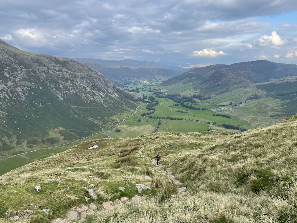
It was a rather surprising encounter as I hadn’t seen anybody in quite some time while making my way up Pike o’Stickle, my last peak of the day, a bit of a scramble as well once you reached the top. Even more surprising to bump into a familiar face, luckily as I was halfway down, no longer in need of the occasional death grip and bumslide to stand my ground.
After exchanging routes, he asked me about the peaks in the distance, some I was able to confirm as I just came from that direction, such as Sergeant and High Raise, others, I had to guess, which initially made me wonder if he was testing my abilities, a default reaction I quickly discarded as I recalled our first encounter the day before, when he did lose half of his group, temporarily…

Same valley, different peaks, I was making my way from Pike of Blisco to Bowfell via Crinkle Crags where a chatty little group asked me to tell their leader to hold up while they were having a short snack break. “You’ll notice him, grey hair, fleece top and all,” they said. I was not quite sure such description would suffice being applicable to the majority of hikers out there, but once I approached the next human gathering, it made perfect sense, his leader aura wafting around, and that head of hair I was bound to recognise again.
I delivered my message, he chuckled, and I carried on. Stopping occasionally to take in the landscape and to check which peaks I was surrounded by, it didn’t take long for the group, now reunited, to catch up with me and call in their second favour of the day, “the last one before she starts charging”, their leader said jokingly. They were after a group picture, as well as answers to a plethora of questions being curious why I’d be wandering out here on my own, armed with a map and compass.
As soon as I mentioned my Mountain Leader (ML) ambitions, our grey-headed hero jumped into action and grabbed a GPS (a green pointy stick, as leaders like to call it) and started pointing at contour lines on my map. No stranger to being mansplained, something to get used to as female in the outdoors, I was ready to lean back and enjoy the ride, listen to his reminiscent tales of navigational feats, ropey encounters and snow hole digging. But instead, he quickly tossed the GPS aside and full-heartedly laughed whilst admitting how terrible he was at it all.
Well, that was unexpected, and rather refreshing setting the scene for the mountainous chinwag amongst pals the following day, a chance encounter, or re-encounter rather, that stuck with me and ultimately became the first thing I kept bringing up when asked about my latest week in the Lake District, a week reminding me why I love(d) the outdoors, a sentiment I decided to share vigorously this summer and ironically, somehow lost along the way.
24 expeds and a broken tent pole later
So, what have I been up to for the past few months whilst neglecting you lovely lot? Well, I fully threw myself into the wonderful world of the outdoors, went from merely leading hikes to teaching navigation and camp craft to our younger generation in pursuit of their Duke of Edinburgh (DofE) Award, as well as a royal handshake if they chose to go for Gold*, literally in that case. When not sleeping in a tent and chasing kiddies around Surrey, Sussex and Kent, I occasionally turned into ‘container girl’ to the amusement of my DofE colleagues whilst working at an outdoor activity centre hosting residential school trips and team building activities which involved zip-lines, climbing walls and campfire nights, amongst other things.
*The DofE scheme is a youth achievement award programme that was founded by Prince Philip, the Duke of Edinburgh, in 1956, to challenge and empower young people between the ages of 14-24 by serving their communities, learning new skills outsides the classroom, and engaging in outdoor adventure, the latter being the expeditions I was lucky enough to supervise and assess this summer. The award has three levels, Bronze, Silver and Gold, differentiated by applicable age range and increasing expectations in terms of skill level and time required for successful completion.
Having good intentions in the beginning, I learned quickly that the outdoors and technology are not the bestest of friends, especially during nippy nights on campsites, a nightmare for batteries, even worse when not the youngest of models, wherefore my laptop got to stay home more often than I did and when reunited, we didn’t really have much to share, I was tired most of the time, he was probably bored, we were slowly growing apart, like a proper old couple.
I know, I know, silly comparison but weirdly, there was some truth to it, at least when it came to my side of the story, as I did eventually hit a wall, I was all camped out, merely rushing from one assignment to the next one, no time to think, let alone write in-between. I can’t remember if it coincided with my lovely little tent giving up on me, but just like its pole, my enthusiasm for the outdoors eventually started to show some cracks and initial excitement turned into dread when looking at my diary.


Don’t you worry, me as well as my tent made it through the season in one piece despite our little existential crisis, but it was definitely high time to figure out where I’d gone wrong, to stick with navigational metaphors. Especially after a Snowdonia trip with a colleague, which was meant to get me back on track, made me feel even more lost than before.
I reached a point where I was not only riddled with doubt about the path I was on, I didn’t even feel like myself anymore. I was far from the girl you met in the opening scene, one I was lucky enough to rediscover during the last big commitment of the year, a commitment that required me to support a “celebration that’ll bring people together over a love of walking and the great outdoors” — oh dear…
Return to the Lake District for a Festival of Walking
To cut a long story short, and finally get you to the most useful section of this post, I decided to press pause on my outdoor ambitions and embrace the event I was due to support for what it was, a festival of walking — the YHA Festival of Walking to be precise, a new initiative the British Mountaineering Council (BMC) and the Youth Hostels Association (YHA) ran for the first time this year throughout England and Wales, offering hostel discounts and free guided hikes led by individuals like myself, in order to get all of us out there, to explore this lovely country, to reap the benefits of nature while going out for a wander, no goals to achieve, only a bit of walking and talking, if so inclined, and that’s what I did.**
**How is this useful for you? Head down to the Bonus section for a navigational treat or two. 🗺️📍🧭⛰️🥾
And you know how it goes, one hike leads to another… and then out of a sudden, you find yourself stood on High Crag, flashing your best explorer-pose, hands on hips, hair waving in the wind, eyes fixed on the horizon, intrigued by something in the distance. You get your map and compass out of your bag, items you pledged to leave behind in the name of fun, but still held on to for moments like this, overcome by curiosity what might be calling for your attention. You orient your map based on your surroundings, find your spot between Nethermost and Dollywaggon Pike. You place your finger right onto High Crag and start retracing your line of sight heading east with a slight northern drift. You pass through Grisdale Forest, fly over St Sunday Crag, drop into the Ullswater Valley between Patterdale and Hartsop and as you start climbing again, there it is, to your utter surprise, Angle Tarn, in all its glory.
Not all those who wander are lost
If returning to the Lake District with a pledge to enjoy myself wasn’t enough to rekindle my love for the outdoors, stumbling across the place where it all began might have been the rediscovery I needed, a physical reminder of that small town girl in zipper pants feeling utterly content whilst sat on a rock in the middle of nowhere watching the world go by, a truly happy camper excited about what the next day might bring — a person and sentiment I somehow lost touch with, …temporarily.
Trying so hard to share the joys with others, to learn everything there was to know, to network and properly explore the outdoor industry, I left no room for myself, no time to think, no time to wander, physically or mentally, no time to get that ‘back burner’ working, and as we all know, that’s where all the good stuff happens.
In addition to that, I was continuously surrounded by super experienced outdoor professionals, seasoned adventurers with lots of tales to tell, youngsters that already made their mark. Inspiring indeed, but also somewhat intimidating. Thinking about it now, it actually reminds me a bit of my travel writing course dilemma — being surrounded by talent, you sometimes stop seeing your own?!
To come full circle and answer the opening question from Mr Explorer, whom I got to meet the day after my (re)discovery: Yes! I’m still out here trying to find my way, be it in the outdoors or with this website. Taking a leaf out of my very own book though, I’m trying to slow down, smell the roses, give myself time to wander, and let things come my way for a change, like this rather fitting quote I’d like to send you off with today:
“Sometimes you’ll stumble. Sometimes you’ll fall. But no matter how lost you feel, if you stay true to yourself, the path will always find you again.” — Eudoria Holmes, Enola Holmes 2

When was I there? 16-24 September 2022
Wanderful Bonus
While you might have missed this year’s iteration of the YHA Festival of Walking, which took place from 4th September to 20th October, a timeframe to note for next year I would say, its routes are still freely available if keen to go on your very own wander. You can find links to various maps and route guides (including QR codes to view the route on the OS maps app) in their Self-guided Walks section.
If curious which walks I got to lead out of the whole lot, here the direct links to the lovely lake and countryside walk from YHA Hawkshead to Tarn How and the hilltop stroll from YHA Keswick to Latrigg offering magnificent views with not too much effort involved.
New to OS maps? Here a free beginner’s guide that might be helpful, one I used myself to start with: Ordnance Survey Map Reading: From the beginner to the advanced map reader
If no OS novice and more interested in what I got up to on my own in-between, here a list of those walks, or Quality Mountain Days (QMDs) as we would call them amongst MLs:
The Old Man of Coniston
- Circular hike from Walna Scar car park (paid)
- Waypoints: Big Hill, Subthwaite Crag, Disused Quarries, Low Water, The Old Man, Brim Fell Rake, Swirl How, Prison Band, Sam Bottom, Levers Water, YHA Coniston Coppermines, Miners Bridge
- Distance: 12km
- Total ascent: 864m
Helvellyn and Nethermost Pike
- Circular hike from Wythburn car park (usually paid but out of order that day)
- Waypoints: Birk Side, Helvellyn, Nethermost Pike, High Crag, Dollywaggon Pike, Grisdale Tarn, Pass of Dunmail Raise, Red Brow
- Distance: 12km
- Total ascent: 945m
Pike of Blisco to Bowfell
- Circular hike from car park next to the Old Dungeon Ghyll bar (paid)
- Waypoints: Redacre Gill, Pike of Blisco, Red Tarn, Great Knott, Crinkle Crags, Three Tarns, Bow Fell, Earring Crag, The Band, Stool End
- Distance: 13.5km
- Total ascent: 1221m
Stickle Tarn to Pike o’Stickle
- Circular hike from car park down the road from Stickle Barn (paid)
- Waypoints: Stickle Ghyll, Tarn, Sergeant Man, High Raise, Thunacar Knott, Harrison Stickle, Pike of Stickle, Loft Crag, Mark Gate
- Distance: 11.5km
- Total ascent: 912m
Skiddaw Man and Skiddaw House
- Circular hike from car park at the foot of Latrigg, on the Cumbria Way (free)
- Waypoints: Jenkin Hill, Little Man, Skiddaw Man, Sale How, Skiddaw House, Cumbria Way past Burnt Horse, Lonscale Crags, Whit Beck
- Distance: 14.5km
- Total ascent: 819m